Friday, May 26, 2006
Interesting Artist
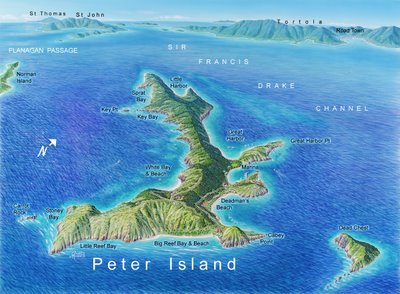
I was surfing the web and came across an artist whose work looked familiar for some reason. His name is James Niehues and he is the artist who painted the images for the trail maps of many of my favorite ski areas. I had always been curious why the trail maps for many ski areas looked so similar and had guessed that perhaps they were computer generated. It turns out that the reason they look similar is because the same artist painted them all. He also does artwork for other resorts including this image of Peter Island in the BVI:


Subscribe to:
Post Comments (Atom)
4 comments:
"While the lights of St. Thomas lie twenty miles west, I see General Electric's still doing their best."
In real life can you actually see St. Thomas from Peter Island? The song was written on Jost Van Dyke, I believe. And yes, before you correct Mr Buffett (and me) I know GE has nothing to do with the electical supply on St. Thomas.
How very odd a coincidence. Before looking at the text, as the picture began to emerge over my slow dial-up connection, I first thought, "What's Litoralis doing posting the map of Taos Ski Valley?"
What fantastic recollections this map of the BVI's is bringing up!
Tillerman: from what I remember from my charter trips to the BVI, when you are in the Francis Drake Channel you can pretty much see all the islands. But I think St. Thomas would be behind St. John when you were on Peter Island, so I don't think you'd be able to see it from sea level.
Post a Comment